Mapping Louisiana: Louisiana Maps from 1513 -1900
Description
The Louisiana Research Collection's renowned map collection extends from 1513 to the present. With more than 400 maps from before 1799, its holdings include state and regional topographic maps, maps of vegetation zones and natural resources, parish and highway maps, and plans of New Orleans tracing the city's development since its founding in 1718. The maps preserve a variety of information ranging from the names and locations of Indian tribes, land owners, plantations, towns, and fortifications, to explorers' routes, depth soundings for the Mississippi River and coastal waters, state and parish boundaries, crops under cultivation, and even the best spots for fishing.
Pages
-

-
A map of North America with the European settlements & whatever else is remarkable in ye West Indies from the latest and best observations
-

-
A map of Part of West Florida, from Pensacola to the mouth of the Iberville River, with a view shew to the proper spot for a settlement on the Mississippi
-

-
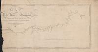
Map of Red River with its bayous and lakes in the vicinity of the Raft. Surveyed by Chas. A. Fuller�January, 1855.
-

-
Map of Red River with its bayous and lakes in the vicinity of the Raft. Surveyed by Chas. A. Fuller�January, 1855.
-

-
Map of the battle-field of Thompson's Hill Port Gibson showing the Positions of the 9th Div. 13th Army Corps Commanded by Brig. Gen. P.J. Osterhaus May 1, 1863. Sketched by F. Tunica, Engineer.
-

-
A map of the country comprised in the state of Mississippi
-

-
Map of the Gulf of Mexico and Antilles
-

-
Map of the Gulf of Mexico and the Isles of America
-

-
Map of the Military Operations in the Vicinity of New Orleans & Port Hudson
-
-
Map of the Red River in Louisiana
-

-
Map of the South Western District Louisiana. Washington, W.J. Stone, 1855.
-

-
Map of the Southern States and Part of the Western
-

-
Map of the states of Mississippi, Louisiana and the Arkansas Territory.
-

-
Map of the states of Mississippi, Louisiana and the Arkansas Territory.
-

-
Map showing anticipated results from improvements proposed. (A.F. Wrotnowski, C.E. 1874). E.H. Angamar, Asst. State Engr. Plate IV.
-

-
Map showing Bayou Rapids. (A.F. Wrotnowski, C.E., 1874) Navigation Co.'s Canal above Alexandria. Prepared to accompany special report of Board of State Engineers, 1874. Plate. VIII.
-

-
Map showing improvements contemplated to secure permanent navigation between the Mississippi, Red and Archafalaya Rivers. (A.F. Wrotnowski, C.E., 1873). E.H. Angamar, Asst. State Engineer.
-

-
Map showing the landing of the British Army
-

-
Map showing the landing of the British Army
-

-
Map showing the landing of the British Army
-

-
Map showing the landing of the British Army
-

-
Map showing the relative positions of the Mississippi, Red and Atchafalaya Rivers after the completion of Shreve's Cut-off (1831)-1866. Compiled by A.F. Wrotnowski, C.E. to accompany special report of Board of State Engineers, 1873. Plate II.
-

-
Map showing the relative positions of the Mississippi, Red and Atchafalaya Rivers from 1578 to 1831. Compiled by A.F. Wrotnowski, C.E., to accompany special report of Board of State Engineers, 1874. Plate I.
-

-
Mapa de las lineas de transporte tributaries los intereses comerciales de Nueva Orleans preparado para la Bolsa Mercentil Mexicana Centro y Sur Americana.
Pages